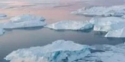
 Icebergs near Ililissat, Greenland.Photo credit: Mark Garten, UN PhotoCOLUMBUS, Ohio—The glaciers and ice caps that dot the edges of the Greenland coast are not likely to recover from the melting they are experiencing now, a study has found.
Researchers report in the current issue of the journal Nature Communications that melting on the island passed a tipping point 20 years ago. The smallest glaciers and ice caps on the coast are no longer able to regrow lost ice.
The current study suggests that the melting of Greenland’s coastal ice will raise global sea level by about 1.5 inches by 2100.
 Ian HowatPhoto courtesy of Ohio State UniversityThe find is important because it reveals exactly why the most vulnerable parts of Greenland ice are melting so quickly: the deep snow layer that normally captures coastal meltwater was filled to capacity in 1997. That layer of snow and meltwater has since frozen solid, so that all new meltwater flows over it and out to sea.
It’s bad news, but not immediate cause for panic, said Ohio State University glaciologist Ian Howat, part of the international research team that made the discovery.
The findings apply to the comparatively small amount of ice along the coast only, he explained—not the Greenland Ice Sheet, which is the second largest ice cache in the world.
“These peripheral glaciers and ice caps can be thought of as colonies of ice that are in rapid decline, many of which will likely disappear in the near future,” said Howat, associate professor of earth sciences at Ohio State. “In that sense, you could say that they’re ‘doomed.’ However, the ice sheet itself is still not ‘doomed’ in the same way. The vast interior ice sheet is more climatologically isolated than the surrounding glaciers and ice caps.
“Also, since this ‘tipping point’ was reached in the late 90's before warming really took off, it indicates that these peripheral glaciers are very sensitive and, potentially, ephemeral relative to the timescales of response of the ice sheet.”
Were all of Greenland’s coastal ice to melt away at once, global sea level would rise a few inches. For comparison, were the whole Greenland Ice Sheet to melt away at once, global sea level would rise 24 feet.
 Learn more about this research via an interactive website from Utrecht University.Image credit: Utrecht UniversityThe problem lies between fresh surface snow and the ice, in a layer of older snow called the firn. Normally, meltwater drains through gaps in the firn down to the ice surface, where the bottom layer re-freezes. That’s how glaciers and ice caps grow.
When the firn around Greenland’s edges became fully saturated 20 years ago, it froze through from bottom to top. Since then, there haven’t been any gaps to capture meltwater, and the ice hasn’t been able to grow.
At the time, researchers couldn’t have known, because they lacked three things: a high-resolution topographic model of the glaciers, a detailed map of glacier boundaries, and a high resolution numerical model of drainage processes.
Howat provided the first two with his Greenland Ice Mapping Project Digital Elevation Model, which offers 30-meter resolution over the entire Greenland surface. Then his colleagues were able to use that data to boost the resolution of their numerical model and get a better idea of where and how the ice caps and glaciers were losing mass.
They found that, for the last 20 years, mass loss has been exactly equal to the amount of meltwater runoff lost to sea. Simulations showed that a frozen firn was the most likely cause.
The Greenland Ice Sheet is subject to the same danger, Howat said, but to a much lesser degree than the isolated bits of ice on its edges.
The real value of the study is that provides “more evidence of rapid change and how it happens,” he added.
Coauthors on the paper are from Utrecht University and Delft University of Technology in the Netherlands; the University of Zurich and University of Fribourg in Switzerland; the Geological Survey of Denmark and Greenland; and the Norwegian Polar Institute.
The research was funded by the Polar Programme of the Netherlands Organization for Scientific Research, the Netherlands Earth System Science Centre, NASA, the Programme for Monitoring of the Greenland Ice Sheet, and the Danish Energy Agency. All maps were designed and processed using the free geographic information system software QGIS.


